Showing posts with label Knoydart. Show all posts

Tuesday, 24 October 2023

Remembering John Hinde & Skye Trek

Skye Trek students on the narrow path above Lochan Leum an t-Saigairt in Glen Pean, 1983

Back in the early 1980s I spent three summers working for Outward Bound Loch Eil leading backpacking trips across Knoydart and the Isle of Skye to Glen Brittle. The course was the brainchild of the late John Hinde and was called Skye Trek. John was a top mountaineer and a veteran of RAF Mountain Rescue. I learnt a great deal from him on those trips. Each course consisted of three groups, all setting off from different points on the edge of Knoydart. Given the terrain of both Knoydart and Skye these were tough walks for the teenage participants, many of whom had never been camping or hillwalking before.

Skye Trek group in Glen Pean, 1983

By coincidence I had recently found a couple of old B&W prints of one of my Skye Trek groups when I read this post  by David 'Heavy' Whalley, another mountaineer and ex-RAF Mountain Rescue leader, in which he mentions John Hinde and refers to a blog of John's diaries put together by John's daughter, Fiona Wild. This blog contains an account of a 1983 Skye Trek on which I was one of the group leaders. Reading it brought back many memories of John and those trips. I had been thinking about Skye Trek earlier in the year too, when I followed much of the Knoydart sections of the treks, as described here and here. With Tony Hobbs I followed the same route through Glen Pean shown in the photos from forty years ago.

In his Course Director's Notes John writes "several Primus stoves were damaged by irresponsible students, and it is suggested that Trangias might be more “student-proof” alternatives for next year" (this did happen). The Primus stoves were the old paraffin type with the burner sitting atop the fuel tank which had to be pressurised with a pump. This brought to mind an incident when John and I had retired to our sleeping bags upstairs in Pean Bothy leaving the students chatting downstairs. Suddenly there was an almighty bang and a big thump on the floor. Charging downstairs we discovered that the students had blown the burner out of the stove by seeing how much they could pump it. Luckily nothing caught fire. 

By another coincidence I was thinking of this episode when I read a news report  today of a gas stove catching fire and being thrown out of a bothy where it exploded. Take care with stoves in bothies! (And tents). 


Wednesday, 7 June 2023

Six Passes & One Hill: A Walk In Knoydart part two

Camp by the Allt Coire na Cruaiche

After my companion for the first five days left (see my last post) I walked back up Glen Dessary past where Tony and I had camped hoping that the sunny weather would last. It didn’t. By the time I left the trees the sky had clouded over and the wind was strengthening. I camped on a little knoll above the river and watched as the clouds descended over the mountains.

Camp in Glen Dessary

My sketchy plan for the next week or so was to visit some places I hadn’t been to in many years and perhaps climb some hills – but only if they were cloud-free. After navigating over Carn Mor in mist and rain with Tony I decided I’d rather stay low and see what was around me than repeat the exercise. I’d climbed all the hills in the area quite a few times anyway and had views from most of them. If I hadn’t done so I’d probably have felt more pressure to reach the summits. As it was there was just one hill I’d only been up once before and that on a day of low cloud and rain so I’d seen nothing. I did hope I might have a clear day for an ascent this trip.

View down to Loch Nevis

The clouds still hanging low over the hills I took the low route from Glen Dessary to Loch Nevis via the Mam na Cloich Airde and Lochain a’ Mhaim. Rain and wind swept the 314-metre pass. 

Lochain a' Mhaim

As I descended I met a party of youngsters with an instructor heading up Sgurr na Ciche hoping the weather would improve. They would be disappointed. They told me they were camping outside Sourlies bothy. Passing their cluster of tents my mind went back forty years to when I’d led groups for Outward Bound Loch Eil on two-week backpacking trips through Knoydart and then across the Isle of Skye. We’d often camped here. I was to think of those times often in the next few days.

Mudflats & pack, Sourlies

Beyond Sourlies I was faced with a sea of cotton grass covering the marsh at the mouth of the river Carnach. A path is marked across this bog. I couldn’t find it – or at least I found many narrow paths but none following the line on the map. The next morning I watched three groups weaving about here, trying to find a dry way through. I doubt they succeeded. My boots were already soaked anyway.

Waterproofs drying on old fence posts at the camp by the river Carnoch

At least there was a sturdy bridge, recently rebuilt, across the river. Back in the 1980s I remember having to ford. I camped by the Carnoch ruins watching deer grazing in the marsh. The rain stopped and I was able to dry some damp gear. Hidden in the cloud not far up river was Ben Aden, the one hill I wanted to climb. Next day, if the cloud lifted.


It didn’t. The cloud was even lower in the morning and rain fell steadily. Climbing the steep zigzags to 549-metre Mam Meadail I was soon in the mist. I reckon the cloud base was about 400 metres. A long gentle descent and I was in Inverie, the only village in the area and the only one in the UK that can only be reached over the mountains or by sea, making it a special and unique place. Here I camped on the Long Beach, a basic campsite facing the sea.

Long Beach, Inverie

I’d intended on spending a day in Inverie from the start as I hadn’t been here since my walk over all the Munros and Tops, twenty-seven years earlier. Since then there’s been a community buy-out of the Knoydart Estate and it’s now run by the Knoydart Foundation, which is based in Inverie, and aims “to develop a sustainable model based on Community, Climate Change and Biodiversity”.

Not dried food!

Sadly The Old Forge pub was closed for renovation. However the Knoydart Pottery and Tearoom and The Look Out restaurant (both highly recommended) provided breakfast, lunch, and dinner to give a welcome change from the dried food I’d been eating for the last week. That camping food was replenished from the community-owned Knoydart Shop.

The ferry leaves for Mallaig

In Inverie I watched the ferry from Mallaig come and go, wandered far out into the bay at low tide, ambled through the lovely woods, and generally relaxed. The sun shone. All day. The only time in the trip when it did.

A misty morning at Barrisdale

The clouds were already gathering when I left Inverie and by the time I reached Mam Barrisdale, my next pass, it was raining. Wetly I plodded down to Barrisdale Bay to camp on the grass opposite the bothy here. If it had been dry I’d have continued up Glen Barrisdale but it wasn’t, so I didn’t. I was just happy to get inside the tent. The rain did stop briefly in the evening and I wandered down the track to the little jetty thinking again of the Outward Bound groups and how we’d catch the ferry across Loch Hourn to Arnisdale from here.

Upper Glen Barrisdale

By dawn the mist was almost down to sea level and everything was hazy and indistinct in the damp air. The air cleared and the sun came out as I walked up long Glen Barrisdale, and the lovely wild upper part of the valley was a delight. I couldn’t remember ever coming this way before. 

Loch an Lagain Aintheich

After crossing a low pass by lovely Loch an Lagain Aintheich I descended the straight line of Gleann Cosaidh to Loch Quoich. The water level was very low; indeed this side of the mountains was very dry. I followed the reservoir loch round to the twin dams at its head (there are dams at both ends) and then camped beside the Allt Coire na Cruaiche with Ben Aden rising not far away. I so wanted the weather to hold for an ascent!

On Ben Aden

It did. I set out the next morning in sunshine for the steep and rocky ascent to the fine little summit. Clouds did sweep in and cover the sky but they stayed above the summits for once and I had extensive views. It may not be a Munro but Ben Aden is a magnificent mountain.

Lochan na Cruadach, Ben Aden on the left

The dry weather lasted for the final two days, though the sky was cloudy and there was a fierce wind. I wandered along the bare stony shore of Loch Quoich – GPS suggested I was in the water – then up to an unnamed pass, at 662-metres the highest of the walk, and down into long, wide, flat, Glen Kingie. The Knoydart roughness had gone. Here the hillsides were green and smooth (relatively). A last camp by the river and then a last pass, where the wind made walking difficult though it was only 458-metres high, and down to Strathan and the long drive home.

Camp in Glen Kingie

Unintentionally this had become a somewhat nostalgic trip. I had forgotten I had so many memories of the area. It was good to go back, despite the weather. Maybe the weather was the reason for the nostalgia. I’d had so many rainy Knoydart trips.

Tuesday, 30 May 2023

Carn Mor The Hard Way: A Walk In Knoydart part one

Loch Morar from the ascent to Meall nan Each

Rain and wind spattering and blowing against the tent woke me several times. It was the first night of a two-week trip in the wild of Knoydart in the Western Highlands, a place noted more for wet weather than sunshine, and also for the ruggedness of the terrain, hence being known as The Rough Bounds.

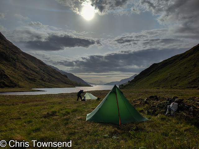
First camp: Glen Pean

For the first five days I was with Tony Hobbs, on his first visit to the area, and his dog Lassie. We’d met in the afternoon at the end of the long rollercoaster road stretching from the Great Glen to the head of Loch Arkaig and walked for few hours along Glen Pean before camping beside the river. My plan was to walk through Glen Pean and descend Gleann an Obain Bhig then return to Loch Arkaig over 829-metre Carn Mor. Four days for this I thought, leaving a day for an ascent of 718-metre An Stac with light packs.

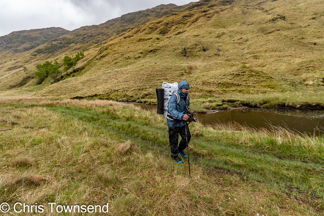
In the rain in Glen Pean

By the end of the second day I’d realised we didn’t really have a spare day for An Stac and that idea was abandoned. The walk through Glen Pean, mostly in wind and rain, had proved quite arduous. 
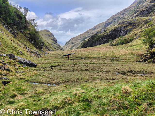
Kayak Man

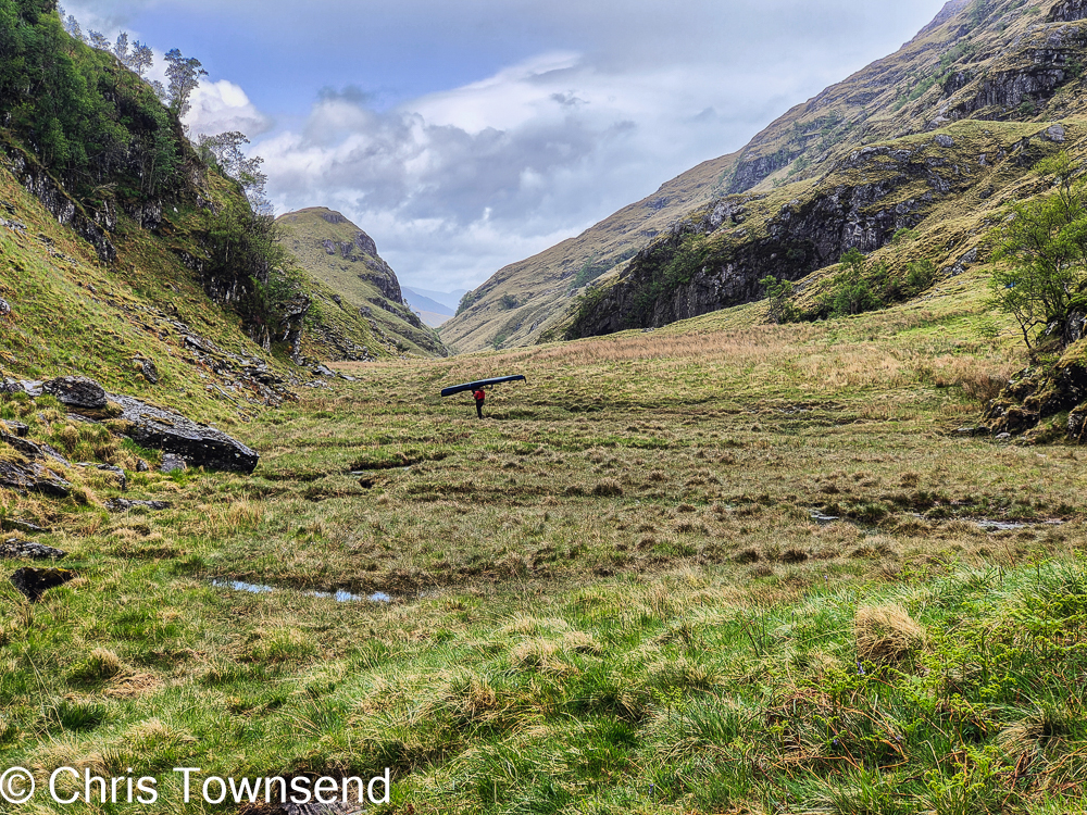
This is a wonderfully wild and dramatic glen but not that easy to traverse, though much easier for us than the man we met with a kayak on his head. He was portaging the kayak and a massive amount of gear from Loch Morar to Loch Arkaig and this was his fourth trip through the massive rockfall at the head of Glen Pean. We’d already passed two big bags of gear plus a trolley and a paddle and wondered about them. I reckoned they must belong to a group, though the paddle was puzzling. I hadn’t thought it would be just one person lugging all this stuff and a kayak through the mountains.

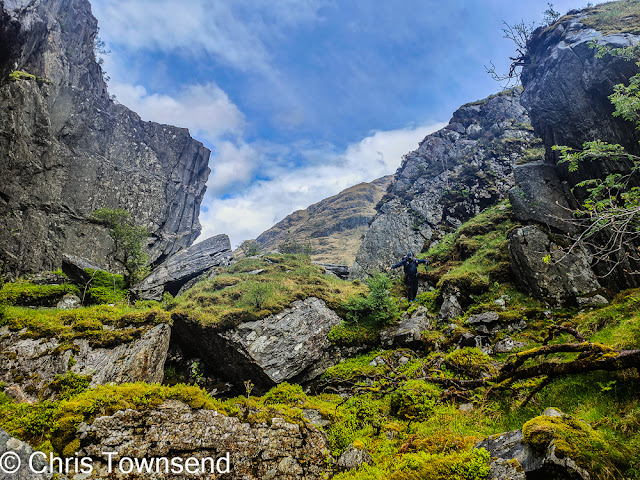
Tony finding a way through the rocks

At least he wouldn’t have to lug everything up and down the narrow path that crosses steep slopes high above the crags that fall into little Lochan Leum an t-Saigairt, which we’d just done when we met him. There the kayak would be useful. Getting it through the rocks where Glen Pean narrows at its head must have been extremely difficult though. This tremendous place is a glorious confusion of massive boulders and crags and green with trees and moss, a tiny sliver of temperate rainforest.  We found an intricate way through this tangle of vegetation and rock amazed that anyone could manage to transport a kayak here.

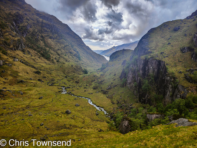
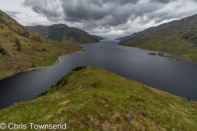
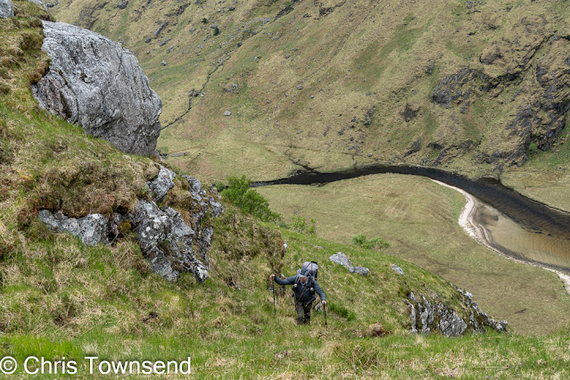
The view down to Loch Morar

Once through the chaos there was a wonderful view down Gleann an Obain Bhig to Loch Morar. As we descended this glen the rain and wind eased and we set up camp not far from the loch in the dry.

Second camp: the sun starts to appear

There was more rain overnight though and the next day came with low clouds, gusty winds, and showers. Not an ideal day for a steep climb to rocky summits but we decided to go anyway. The climb up onto the west ridge of Meall nan Each, which we had to cross to reach Carn Mor, was very steep, rising some 350 metres in less than a kilometre. The pathless terrain was very rough too, a mass of tussocks, bog, and rock. Hand and occasionally knees were used at times.

Tony on the ascent to Meall nan Each

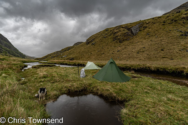
By the time the angle eased the wind was stronger and the cloud was not far above. After crossing Meall nan Each we spent a while searching for a reasonably sheltered site, eventually finding one at the head of a shallow gully just below the ridge. There wasn’t really room for either of our shelters but we managed to squeeze them in with just enough room to lie down. I reckoned it was better doing this than camping on more spacious but much more exposed sites a little higher up.

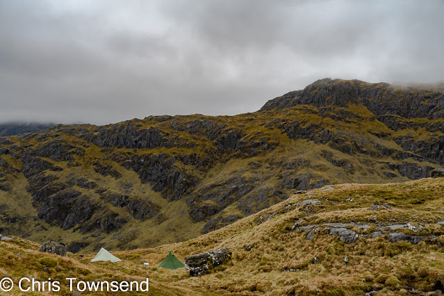
Third camp: somewhere on Meall nan Each

The storm continued all night and into the next day. Heading for Carn Mor we were soon in the cloud and needed to keep a careful watch on our navigation as we threaded our way through the complex rocky and boggy terrain. The summit came and went in mist and rain – the views are probably excellent!

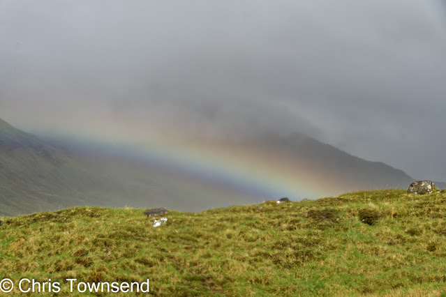
The storm starts to fade

The roughness lessens beyond the summit and the going and navigation were both easier. A flash of rainbow below us marked the fading of the rain and cloud too and soon after we reached the edge of the forest in Glen Dessary the sun was coming out. Finding dryish and flattish spots to camp wasn’t easy and we ended up out of sight of each other.

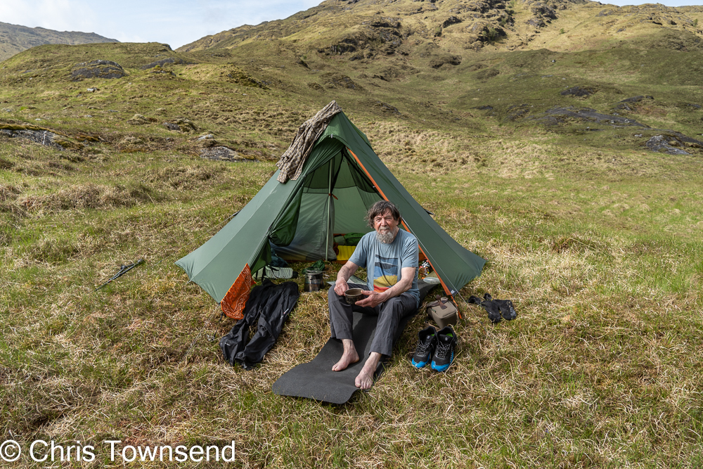
Fourth camp: Glen Dessary

The final day was just a stroll in the sunshine, mostly in the forest, back to our cars. Here Tony headed off on the long journey back south. I restocked my food supplies and swapped some items of gear then set off again, this time for a solo eight day walk. I’ll tell that story in my next post.

Enjoying the sun and airing damp gear at the Glen Dessary camp

Tony recorded a great deal of video during the walk, including a chat with me about the gear I was using for his
You Tube channel. That chat and four other videos are already online and Tony says there will be two more. Tony’s perspective on our trip is interesting!