Friday 30 September 2022

Clouds & fungi and dampness on Meall a'Bhuachaille

Late afternoon brightness far to the west

September has ended with a week of stormy weather, culminating in a day of torrential rain and ferocious winds. The day before there was a brief weather window, the afternoon looking dry and not too windy, so I went to the Ryvoan Pass and Meall a'Bhuachaille to see how far autumn had progressed in the woods and in the hills.


The air was still and humid, the woods wet and silent. Birches had touches of yellow, the bracken was beginning to fade. One bronze frond stood alone, startlingly bright in the rain-dulled forest. Fungi lined the path, yellow, red and brown.

Spiders webs picked out by raindrops covered clumps of heather, always a sign of autumn. 

Leaving the last trees I could see wisps of mist drifting across the gentle rounded dome of Meall a'Bhuachaille below a surging cloudscape. 

As I climbed higher I could see further mists slowly trailing over the damp landscape. On the summit there was a light breeze, just enough to have me donning a shirt over my base layer. It wasn't really cold though and the shirt was off again soon after I started the descent. 

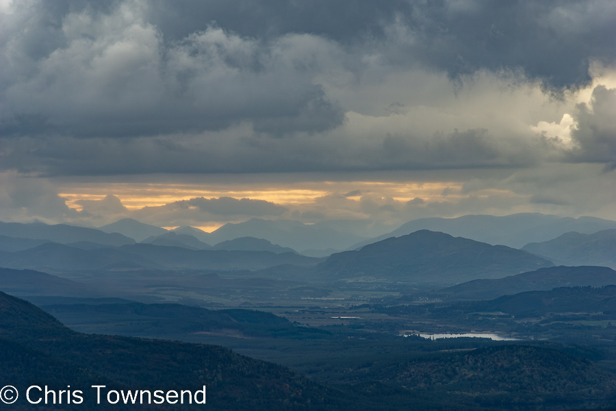
Not far below the summit were more fungi, high above the forest. In the far west a low strip of sky was bright and orange where the sun broke through distant clouds. Then as I entered the trees again there was blue sky above and white clouds piling up into the sky. It didn't last. Light rain began to fall just before I reached the car. 


Wednesday 28 September 2022

My first book was published 35 years ago.

Scott Steiner in camp on the Continental Divide Trail

“Backpacking, travelling in remote places carrying all you need in a rucksack, is a means to freedom, the freedom of the wilderness, a freedom which I have relished over the years and the experience of which I hope to portray here”.

The above words are from the introduction to my first book, The Great Backpacking Adventure, published thirty-five years ago. They’re as true now as they were then.

I enjoyed writing the book, as I have every book since. I wrote it because it was the sort of book I enjoyed reading. My walks had been inspired by books on long walks by John Hillaby, Hamish Brown, Colin Fletcher. I hoped I could entertain and inspire others the way they had me. 


Back then the world was a different place, a much slower place. The electronic revolution was yet to begin. The Internet, GPS, digital cameras, smartphones were all in the future. I wrote the book on an Amstrad computer, bought specially for the purpose, then printed it out and sent it to the publisher along with a selection of transparencies. Remembering that really makes it seem a distant time. Walking in wild places, enjoying and feeling part of the natural world, hasn’t changed thoug


The Great Backpacking Adventure is long out of print. But some of the words I wrote back then seem to ring truer today, sadly.

“Our modern detachment from nature, from the force of which we are a part, our futile attempt to prove ourselves separate from and superior to the ecological system that allows us to live, our view of the world as an enemy to be conquered, and a bottomless treasure chest to be exploited, are the escapist and selfish attitudes that has les us to the brink of the abyss of annihilation on which we are poised. Re-establishing our place in the natural scheme of evolution and the real world is essential if we are to have a future”.

And the final lines:

“I pack a rucksack and head off into the hills to pitch my tent, gaze at the sky, feel the wind and rain on my face, the rocks and earth under my feet and bring my life back to the only thing that exists, the present”.

Saturday 24 September 2022

40 Years Ago I Finished My Pacific Crest Trail Thru-Hike

Monument 78, September 24

On the 24th September 1982 I finished my walk along the Pacific Crest Trail at Monument 48 on the USA/Canada border. It was pouring with rain. I didn't mind. I'd just had the greatest adventure of my life. My only regret was that it was ending. 

View from Fire Creek Pass, September 17

The last two weeks of the walk were spectacular as the trail passed through the dramatic alpine mountains of the North Cascades. They were tough weeks too as over and over again the trail climbed to high passes, descended into deep valleys, then climbed straight back up to another high pass. But after over 2000 miles (3200km) of backpacking I was very fit and found the walking easier than back in the much gentler terrain at the start in faraway Southern California. 

Autumn larches at one of my last camps

After the touch of winter at Snoqualmie Pass (see this post) I felt the need to hurry even though I would have liked to draw out these last weeks, stretching every last minute in the mountains and on the trail. But winter was coming. The autumn colours were increasing by the day, the ground a swathe of red. Golden larches shimmering in the forests. Nights were chilly, the ground often white with frost at dawn. Days were hot in the sun but cool in the shade.

Mount Hardy from Methow Pass, September 22

But the weather held until the very last day and the mountains were glorious. This was the most dramatic landscape since the High Sierra. I had wondered if I would be tired of the trail and eager to finish after so many months walking. Not here, not in this magnificent landscape. I felt I could have walked here forever.

Cutthroat Pass, September 22

I couldn't of course. In two days I would be back home. The PCT would live with me forever though and my appreciation and joy in the walk would deepen over the years. 

The full story of my PCT hike is told in my book.


Tuesday 20 September 2022

The other Huntly's Cave

Uaigh Mhor & Huntly's Cave

Huntly’s Cave is a popular rock-climbing crag set in a deep ravine with the Allt an Fhithich (Raven’s Burn) running through it. The crag lies a few miles from Grantown-on-Spey just off the A939, known locally as the Dava Road as it crosses Dave Moor. The Dava Way, which follows the old railway line from Grantown to Forres, passes close by. UKclimbing.com lists 31 climbs on the crag.

The cave that gives its name to the crag is named after George Gordon, 2nd Marquis of Huntly, who is said to have hidden here after his Royalist force was defeated in the early 1640s. His son is also said to have hidden here not long afterwards. (Information from Place-Names Around Grantown-on-Spey by C.J.Halliday).

However, there is another Huntly’s Cave just four kilometres to the north-east that’s far less well-known. Not much information is available on this cave. Halliday just comments that “it’s said one of the lords of Huntly found refuge here while proscribed by the government”. It lies in a little ravine, the Uaigh Mhor (Large Grave), in an attractive small rocky area on the boggy moorland west of Carn na Loine (Hill of the Marsh) on the northern border of the Cairngorms National Park.

After passing close by many times over the years – as with so many local places I’ve been meaning to “get round to” - I finally decided to go and have a look at it on a day of low cloud and drizzle when the high hills didn’t seem attractive. 

Starting out from home through the local woods I discovered recent storm-felled trees on top of the not-quite-so-recent ones, making the going interesting in places. The woods were damp and autumnal. There were many fungi. 


Once through the trees I was soon on the estate track that runs through the open moorland around the head of the Allt Breac (Speckled Burn). The rocky area holding Huntly’s Cave stands out amongst the bleak expanse of sheep-cropped and muir burned heather. It makes up the eastern side of 420-metre Carn a’ Ghille Chearr (Hill of the Left-Handed Lad) and the little crags are dotted with small pines and birches. The Uaigh Mhor lies at the northern end of the crags and runs down to the track.

The Uaigh Mhor

Whilst only some 150 metres in length the Uaigh Mhor makes up for this with its roughness. A tangle of dense juniper bushes, deep heather, rocks, and boulders makes for slow progress. There’s no path. Why it’s meant to resemble a grave I couldn’t work out – maybe with less vegetation it would be clearer. 


The cave lies near the top end of the ravine, a narrow damp cleft under a boulder. It’s around three metres deep with enough space for two or three people to sit uncomfortably. The floor is sloping and rocky. You would have to be desperate to spend a night here.


From the cave I clambered out of the top end of the ravine and then followed the narrow ridge above back to the track. Another rocky ravine lay on the other side of this. There are many pines. This is a delightful little wild area in complete contrast to the moors just below. I enjoyed my mini expedition and I’ll be returning to explore more thoroughly.