Showing posts with label landscape. Show all posts

Tuesday, 15 July 2025

A Heatwave Walk In A Doomed Landscape

Lochan na h-Earba

Hillwalking in a heatwave is hard work, especially carrying camping gear. The forecast was for a few days of clear skies and light winds when I planned the trip. After became a forecast for a heatwave I decided to go anyway and modify my plans if necessary.

I’d been planning to visit the Ardverikie area south of Loch Laggan since March when the Scottish Government granted permission (see here) for a huge pumped storage scheme that will drastically change this wild area. I wanted to see it again before it became a different and diminished place.

Foxgloves & the Abhainn Ghuibinn

I set off late, hoping to avoid the hottest part of the day. I don’t know if I did but it was certainly very hot, the air still and heavy. The land looked lush and green. Lines of red and white foxgloves edged the track. As long as I kept my place slow it was lovely walking.

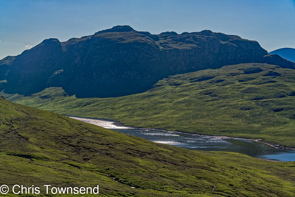
Soon I reached Lochan na h-Earba under the walls of craggy Binnein Shuas, only 747 metres high but a rugged hill with a classic rock climb, Ardverikie Wall, on its cliffs. At the southern end of the lochan is a golden sandy beach, a lovely spot. A few tents dotted the grass at the sand’s edge. It is a grand place for wild camping.

Lochan na h-Earba

Lochan na h-Earba is a double lochan as the same name applies to the next lochan in this narrow glen between steep hills with just a half kilometre of flat land, Am Magh, between them. When the hydro comes this will disappear under the waters of a reservoir as the twin lochans become one with dams at both ends. That will be a sad day.

I considered joining the campers by the beach but there were still several hours of daylight left so I pushed on up a steepening stony path into Coire Pitridh and then to the Bealach Leamhain at almost 750 metres. Here I pitched my tent on rough ground that was probably boggy in wet weather. This night it was dry enough.

Loch a' Bhealaich Leamhain evening

Just beyond my camp I could look down on Loch a’ Bhealaich Leamhain, a jewel set between the steep rugged walls of two Munros, Beinn a’ Clachair and Geal Charn. This will be the upper loch of the hydro scheme, with a large dam at one end. Low sunlight lit the grasses on the bealach. The waters of the loch shimmered in the breeze. The sky and the hillsides glowed. A wild peaceful place. For now.

Bealach camp

I settled into my tent. The light wind kept off the midges for a while but died away as it grew dark. A few bites and I had the doors zipped shut, even though it was quite stuffy inside. The air did cool in the darkness though, dropping to 12°C, and I was able to sleep for several hours, until the rising sun woke me with brightness and a rapidly rising temperature.

Loch a; Bhealaich Leamhain morning

I wandered over to look at the loch again. The water was a deeper blue, undisturbed except for one little whisper of wind. The grasses glowing in the sunshine again but the slopes either side were shadowed. It felt an enchanted place.

By the time I set off the heat was building rapidly. A rough path took me up to the col between Creag Pitridh and Geal Charn. I had intended on climbing the former, another Munro, as it’s less than 100 metres above the col and just half a kilometre away before heading up Geal Charn but I was already feeling the effects of the heat and not quite enough sleep. A rest seemed much more attractive, especially as I found a shaded spot behind a boulder. It’s not often conditions are right for a nap outside during a summer’s day high in the Scottish hills, midges or the weather usually moving me on quickly. I was glad to take advantage of the opportunity.

Creag Pitridh

The rest lasted two hours, at least half of which I spent asleep. I felt rested and relaxed. So relaxed I could have stayed there all day. I wanted to climb Geal Charn though, or rather I wanted to descend Geal Charn. On the map I’d noticed a path marked on the north side of the hill that eventually curved down to Am Magh. I’d found no mention of it in any guidebook. Did it still exist? I wanted to find out. The situation looked excellent as it traversed across steep slopes high on side of remote Coire an Iubhair Mor.

Geal Charn

A steep stony path led up to the extensive plateau-like Geal Charn, a path not marked on the map, though it is well-used and described in every guidebook. As the path levels out the distinctive summit cone appears, its sides strewn with the pale stones that give the hill its name – Geal Charn meaning white hill.  On some maps it also has the alternative name Mullach Coire an Iubhair, the top of the corrie of the yew tree. I could see no trees in the corrie below nor did it seem likely that yew trees ever grew this high.  There’s a big well-built cairn and a circular trig point on the top. I rested here a while, enjoying the extensive view. In the sun my thermometer read 42°C. There was a breeze though, which took the edge off the heat.

Summit cairn and trig point

A short descent led to the steep edge of Coire an Iubhair Mor. I could see the path not far below and follow its snaking line across the corrie wall. It looked even better than on the map, and better still when walked. It’s well-constructed and wider than a walker’s path, made, I think, for ponies. In places it’s fading away, in other crumbling and narrow, but still easy to follow. The only tracks I saw were those of deer. Not far below a little lochan lay in the heart of the corrie.

Marvellous & neglected

I thought this path lovely and easily the best way up Geal Charn, which is an underrated hill. But I could see why the path was neglected. It’s on the wrong side of the hill for combining Geal Charn with Creag Pitridh and Beinn a ‘Clachair, the round of these three Munros being a standard route and recommended in every guidebook.

Looking back up the path to the rim of Coire an Iubhair Mor

Leaving the corrie rim the path ran down to the Allt a’ Mhaigh (Moy Burn). As I descended the breeze dropped away and the air became stifling. The clegs (horseflies) came out and I wasted precious energy slapping them away. Despite this and adding insect repellent to the sunscreen and sweat I was still bitten painfully a few times, smears of blood decorating my arms and legs.

Loch na h-Earba & Binnein Shios

Lower down the path faded away into boggy ground. I could see the north-easterly Lochan na h-Earba and craggy Binnein Shios, a companion to Binnein Shuas. Soon I was down on Am Magh and the estate track that runs along this long glen.

Am Magh & Lochan na h-Earba

Am Magh is another lovely peaceful place. There are a few trees here and many more on the flanks of the hills either side of the north-easterly lochan. If I’d been out for a second night I’d have camped here. As it was I tramped the track alongside the other lochan back to the golden beach and on to my car and the main road. The heat didn’t relent and I stopped regularly for water and a rest. I probably drank five times as much as usual on a day out. On the way home I heard that the temperature reached a record 32.2°C in Aviemore, which wasn’t far away.
Binnein Shuas & Loch na h-Earba

I’m glad I visited this area again. It’s how I shall remember it. If the hydro is constructed I doubt I’ll return.

There was a campaign against the hydro scheme. Parkswatch Scotland ran several excellent piece such as Free market landscape destruction by Nick Kempe and Shafting Ardverikie – the fate awaiting its lochs, corries, bens and fine old hill paths by David Jarmin. The last, which I only read after my walk, describes the Coire an Iubhair path.  The John Muir Trust made a formal objection too but all the campaigning was to no avail. A beautiful area of wild land is to be lost.

Tuesday, 2 January 2018

New Years Eve, New Years Day

Across Strathspey to the Cromdale Hills on New Years Day

The old year faded away in soft mist and cloud. The new year began much the same way. Nature doesn't acknowledge or notice our arbitrary division of years. Winter just continues.

The temperatures hung around freezing. The air was still. A slight thaw for a few hours on New Years Eve softened and shrank the snow. Overnight cooling turned the snow crunchy and slippery. Bands of mist drifted along the strath, marking the line of the River Spey, and floated in layers across the hills. The High Cairngorms remained hidden. The land was quiet, waiting, maybe asleep.

Across Strathspey to the Cromdale Hills on New Years Eve

The constantly shifting mists gave an ethereal feel to the landscape. Hillsides appeared and faded away. The hazy Cromdale Hills, sometimes floating above the mist with the long summit ridge rising into clouds, could at times have been Himalayan giants. Strands of mist laced the tops of the forest.

New Years Eve rainbow

Rain and sleet accompanied the New Years Eve thaw, making the air feel colder than when it was dry and the temperature lower. As the dark storm clouds moved away late in the day the sun caught them and a rainbow appeared, a fitting finale to the year.

Dusk, New Years Eve

On both days the clouds began to break and dissolve as the light faded, the sun lighting them gentle shades of orange, red and pink. Subdued sunsets on subdued days. The snow made walking under the darkening sky easy with no need for torches. Then as the clouds thinned some more a hazy moon could be glimpsed, soon strengthening and brightening, a bright aura surrounding it.
 
New Year moon

This, the first full moon of the year, is known as the Wolf Moon (actually full on the 2nd but it looks much the same!). I gazed up, imagining the sound of wolves howling in the woods. If only. Instead there came the soft hooting of owls. Wild hunters of a different sort. Then at midnight a burst of colours and explosions lit the distant sky - the New Year celebrations in Grantown-on-Spey. Across the strath more fireworks in Cromdale. The quiet and the owls soon returned. The year had changed. The owls hooted on, oblivious.

Strathspey, New Years Day

The first day of the new year faded away just as the last day of the old year had, the clouds turning pink in the last rays of the sun. The woods dark, the fields white with snow. The air still. A quiet change.

Dusk, New Years Day


Thursday, 4 May 2017

Thoughts on Water in the Scottish Hills

Stream in spate in the Western Highlands. Unable to ford it safely I had to change my route.

Water is a constant feature of the Scottish hills. Only on the highest, narrowest ridges are you away from water for long and even then you can usually see lochs and rivers far below. Often water is close to hand, whether tiny trickles and pools high in the hills or big rivers and lochs in the glens. Water isn’t just part of the visual landscape either. It’s also part of the outdoor soundscape. The sounds of water are an integral part of the Scottish hill experience; from the crashing of a hill burn down steep rocks to the rattling of rain on a jacket hood the noise of water is often present.

The Carnachuinn Bridge in Glen Feshie was swept away by a flood in 2009. It still hasn't been replaced.

Water is also essential in shaping the landscape. Water has carved out glens and corries, both when frozen in the form of glaciers and as free running water, eroding away hillsides and valley bottoms. This process continues each day with rivers and burns slowly wearing away the hills. Every rain storm has an effect too, often unnoticeable but it is there and over time the landscape changes. Floods have immediate effects, shifting rocks and soils, cutting new river channels and sweeping away banks, trees and, sometimes, bridges and paths.

Path washed away by the Allt Garbhlach in Glen Feshie

The beauty of the landscape owes much to water. The lochs and rivers and waterfalls are all essential to the overall appearance of the hills, shining and shimmering in sunlight, contrasting with the rocks and vegetation. Rain too matters, much as hillwalkers may curse it. Without rain the hills would be brown and parched, desert-like. Without rain the rivers would dry up and the lochs shrivel and fade away.

The Falls of Glomach in Kintail

Water also provides challenges to hill goers, both in the form of rain and turbulent streams. Driving horizontal rain isn’t unusual in the hills and will soon find a way through any weakness in waterproof clothing. Keeping the rain out whilst not getting wet from trapped body moisture is a constant struggle for hillwalkers. Whilst staying completely dry on a day of continuous windblown rain is just about impossible, staying comfortable – not too wet, just warm enough – is feasible with the right clothing. Dealing with rain is also psychological as it’s easy to become fed-up when a storm lasts for hours or even days. A philosophical approach and a consideration of what rain adds to the landscape is required at such times!

A wet day in the Cairngorms

The other challenge from water comes when burns or rivers need to be forded as there isn’t a bridge, which is the case in many parts of the Highlands. Hill streams can rise very quickly after heavy rain; a trickle that could be crossed without getting your feet wet can be an impassable raging torrent when you return a few hours later. People have drowned attempting to ford rivers and burns in spate so great care is needed. I’m very wary of fords following a couple of incidents early on in my Scottish hillwalking career when I was nearly washed away. I can still remember realising half way across one deep torrent that if the water grew any stronger or deeper I wouldn’t be able to keep my feet. Happily it didn’t. Now I’m prepared to go miles out of my way to avoid crossing any stream that looks too strong and I have often backed off after starting a ford.

Tony Hobbs fording a stream in the Western Highlands

Water then can be both a pleasure and a threat. Learning to appreciate it and deal with it is essential to the mountain experience. Without water the Scottish hills would be diminished. It’s part of what makes them what they are.

Cam Loch in the NW Highlands

Wednesday, 6 January 2010

Industrialisation of the Scottish Highlands to go ahead


The Scottish Government has given the go ahead for the line of giant pylons through the Scottish Highlands from Beauly to Denny. These pylons – ranging from 42 to 65 metres high – will run through the western side of the Cairngorms National Park and other areas of landscape beauty and importance and be visible from many mountains. Whilst this act of vandalism was expected it is still a big disappointment as it means the despoliation of the Highlands and the start of a period of mass industrialisation as the line only makes sense if many wind turbines are built in the wilds. This evil scheme means the Highlands will never be as wild or beautiful as they are now. The Scottish government should be ashamed of this attack on their own land as should the former environmentalists such as Friends of the Earth and the Green Party who have welcomed this destruction, showing that they are now the allies of big business and industry and enemies of nature and conservation. It is a sad day for Scotland.

Photo info: the current power line near the Great Glen.

Thursday, 17 September 2009

Landscapes in Space and Time


Last weekend was spent celebrating another decade of life passing by. Ten years ago a group of friends gathered in the hills of the Lake District for my fiftieth birthday. This year we went to one of the flattest places in northern England, the seaside resort of Southport on the Lancashire coast. I was brought up near here at Formby and my mother and one of my brothers and his family still live in the area. It was so that my mother could be present that I went to Southport. Saturday we gathered in a function room in a pub – the Blundell Arms – for talking, drinking and eating. Many of my old friends had not seen each other for many years and the air was thick with reminiscing. Ten years previously we had been in the Old Dungeon Ghyll in Langdale. And the next day some of us had headed up onto the fells. This year the only hills within many miles were the little sand dunes abutting the wide flat expanse of the vast beach that spreads from Southport to Liverpool. It was to the beach we went, to Crosby where the 100 iron men of Anthony Gormley’s Another Place are dotted over the sand from high to low water. Once identical these figures are showing the slow effects of time in changes wrought by the weather and the sea. The iron is rusting, barnacles cover those parts more in water than air, seaweed crawls up legs and twists round feet, faces lose definition and become spooky and alien. Wind blown sand has started to bury some of the figures while with others the wind has scoured away the sand revealing the plinths on which they stand. Beyond the motionless, rigid, dark figures giant pale wind turbines rise out of the sea, slightly hazy, slightly ghostly. These too were still, despite a breeze. Beyond the turbines to the north the sand and sea spreads out to the sky and the simple trilogy of golden rippled sand, dark wave streaked water and paler cloud streaked air is vast, fading into the distance without ending. Turning south the landscape changes and becomes jumbled, complicated, a mass of confusing shapes that are all angles and hard lines. This is Liverpool and the shapes are cranes, cathedrals, sky scrapers and more wind turbines, these ones turning. It’s a much more intense, closed-in landscape than the spaciousness of the sea and skyscape. Turning from one to the other was turning from the freedom and wildness of nature to the restrictions and confinements of the city, both available at a glance. The first is where I live in my head and where I have spent much of my life but I would not be without the second. My friends and family had come together from all over Britain, some travelling long distances. I am aware that modern urban civilisation had made this possible. Reconciling the urban with the wild is a never ending, never completed task, a constant balancing of desires and dislikes as I move through both landscapes in time as well as space.

Photo info: Iron Men & Wind Turbines, Crosby Beach. Canon EOS 450D, Canon EF-S 18-55 IS@55mm, 1/640 @ f5.6, ISO 100, raw file converted to JPEG in Lightroom 2.4.