
Thursday, 31 July 2025

A Look At The September Issue Of The Great Outdoors

The September issue of The Great Outdoors is out now. The cover is a superb photo of Sgurr a'Mhaim taken from Sgurr an Lubhair in the Mamores by James Roddie. The opening spread is equally wonderful and encapsulates the the theme of this issue. It shows nine teams of skiers spread over 7km of the Jostedalsbreen glacier in Norway at night using their headlamps to shine a giant morse code SOS signaL In this case it's because the glacier is threatened both by climate change and a gondola. And that's the theme - action to save mountains and nature and to give ourselves hope.
To this end deputy editor Hanna Lindon meets people working for the mountains from the Himalayas to the Lake District and the Cairngorms. In Scotland photographer Richard Cross uses drone photography to show land issues in a way hard to see on the ground. In the Skills section Detective Constable Paul Flint of Derbyshire's Rural Crime Team gives advice on how walkers can help tackle wildlife crime.
The mountains can revive ourselves too, as Andy Wasley found on a walk in the Dolomites in Italy. Also overseas James Roddie spends two weeks in the spectacular High Sierra mountains in California.
In shorter pieces Nadia Shaikh writes about the common but often overlooked Meadow Pipit; Francesca Donovan reviews Paul Besley's The Search - the life of a mountain rescue search dog team; artist, poet and 'Day of Access' founder Alec Finlay asks who belongs in the mountains and how should they enjoy them; Jim Perrin takes a lesser-known scramble on Yr Wyddfa; and Juls Stodel gives advice on taking dogs hiking and camping.
In the Gear pages Steph Wetherall reviews the Therm-A-Rest Questor 0F/-18C sleeping bag; Fiona Russell reviews the Alpkit Ultra 1 tent; Lucy Wallace compares four solo tents; Gemma Palmer tries six backpacking meals; and Kirsty Pallas and James Roddie each review a pair of three-season sleeping bags.
Wild Walks covers seven walks all reachable by public transport. In the NW Highlands Ian Battersby goes by bus to the Five Sisters of Kintail. In the Central Highlands Alex Roddie crosses Geal-Charn, Aonach Beag and Beinn Eidbhinn on a walk between the railway stations at Dalwhinnie and Corrour. It's back to buses again for Stefan Durkacz's Glen Sax Round in the Southern Uplands. In the Lake District buses give access to St Sunday Crag for Vivienne Crow and Wansfell for James Forrest. In Mid Wales Roger Butler takes the train to explore Wernygeufron Hill and Beacon Hill. Finally, Fiona Barltrop takes a ferry to the Isle of Wight to walk on Limerstone Down and Hanover Point.
Sunday, 27 July 2025
40 years ago on the Continental Divide Trail, 15 years ago on the Pacific Northwest Trail
 |
| The Highline Trail, Pacific Northwest Trail |
On July 27 1985 I reached Macks Inn close to the boundary of Yellowstone National Park and completed the first 815 miles of the Continental Divide Trail. It was day 59 on the trail. I posted a piece on the walk here.
On July 27 2010 I camped by Sinclair Creek in the Whitefish Divide region after the first 118 miles of the Pacific Northwest Trail. It was day 8 on the trail.
 |
| Stahl Peak. PNT. |
At this point both trails were in the Rocky Mountains but the PNT would soon leave them on its journey east to the Pacific Ocean. The CDT of course stays in the Rockies until they fade away in northern New Mexico.
 |
| There were mosquitoes! PNT |
On the PNT the walking was becoming tougher as I'd left the prepared trails of Glacier National Park behind. It was to become much more difficult, both with the terrain and navigation. On this day I still had trails to follow. It began at a mosquito-infested site where I just slept in the inner mesh tent and finished with thunderstorms and rain. Along the way the scenery was superb and the final section on the Highline Trail wonderful.
 |
| There was rain! PNT |
On the CDT the walking was already tough, the hardest in fact of the whole walk as there was much bushwhacking and steep rocky slopes and navigation was often just continue south by the easiest way I could find. I wrote in my journal that the ten days I spent in the Beaverhead Mountains were the "toughest walking I've ever done". I did also note that the rewards were "pristine cirques ... no campsites, no trails, no fire rings, no cut trees ... immaculate scenery".
 |
| Immaculate scenery. CDT |
On the PNT I was half a day's walk from my first rest stop in the little town of Eureka. On the CDT I hadn't had a break for seventeen days when I reached Macks Inn, a small fishing resort. I needed one! In fact I took two.
Ahead the terrain on the CDT would be much easier though as I crossed Yellowstone National Park with its signed maintained trails and backcountry campsites.
 |
| Whitefish Divide scenery. PNT |
A big difference on the walks was my camera gear. 1985 was still film. I haven't yet scanned many of the thousands of images I took. I must do so! 2010 was digital. The images from that walk posted here are ones that didn't appear in my PNT book. All of those with this piece were taken on July 27.
 |
| Fire Lookout on 2205m/7235ft Mount Wam. PNT |
I 've never written a book about my CDT hike but there is a long chapter about it in my first book The Great Backpacking Adventure (long out of print). The cover of that book is of my friend Scott Steiner who accompanied me on the first 500 miles at a camp below the Chinese Wall in Montana.


Friday, 25 July 2025
Monday, 21 July 2025
Sunday, 20 July 2025
Fifteen Years Ago I Set Out On The Pacific Northwest Trail
 |
| At the trailhead, day 1, July 20, 2010 |
On July 20, 2010, I started out to walk from the eastern edge of the Rocky Mountains to the Pacific Ocean on the Pacific Northwest Trail, inspired by writer and backpacker Ron Strickland, who'd come up with the idea for the trail and wirtten the first guidebook. Thank you Ron! It was a wonderful, beautiful, exciting walk.

The trail wasn't as developed as it is now, thanks to the work of the Pacific Northwest Trail Association, but I had Ron's guidebook, which I ripped up and sent to resupply points in sections, and a line on a map to follow. There was much off-trail navigation to deal with though - luckily I love this!
 |
| The Belly River, Glacier National Park |
That first day I hiked trails in the spectacular Glacier National Park, a tremendous start to the walk. I marvelled at the huge forests and snow-streaked mountains, revelling in the wild glory and vastness.
 |
| First camp |
Hiking in Glacier National Park is constrained though. Permits are needed and you have to camp at designated backcountry campgrounds. The first camp of the walk was on the Mokowanis Junction Campground. It would be another three days before I left the national park and permits, campgrounds and trail signs (sometimes the trails themselves) would disappear.
 |
| The guidebook after the walk |
A first on this walk was a smartphone. The iPhone had been launched just three years earlier. I chose an Android phone though, for the sole reason that it had an interchangeable battery so I could carry spares. Good lightweight battery packs were in the future. So was satellite communications. I only had a phone signal in or near towns. I mostly used it for navigation as it had GPS and I'd downloaded maps. I did take some photos which I sent back to The Great Outdoors magazine along with updates typed on the tiny keyboard.
My cameras were all digital. I'd given up film several years earlier. An advantage of digital is that advances in processing means I can now get better results from the images than I could at the time. I'm glad I shot raw files so I can do this.

Back home I wrote a book about the walk. It's out of print but I expect there are secondhand copies around.
Tuesday, 15 July 2025
A Heatwave Walk In A Doomed Landscape
 |
| Lochan na h-Earba |
Hillwalking in a heatwave is hard work, especially carrying camping gear. The forecast was for a few days of clear skies and light winds when I planned the trip. After became a forecast for a heatwave I decided to go anyway and modify my plans if necessary.
I’d been planning to visit the Ardverikie area south of Loch
Laggan since March when the Scottish Government granted permission (see here)
for a huge pumped storage scheme that will drastically change this wild area. I
wanted to see it again before it became a different and diminished place.
 |
| Foxgloves & the Abhainn Ghuibinn |
I set off late, hoping to avoid the hottest part of the day. I don’t know if I did but it was certainly very hot, the air still and heavy. The land looked lush and green. Lines of red and white foxgloves edged the track. As long as I kept my place slow it was lovely walking.
Soon I reached Lochan na h-Earba under the walls of craggy
Binnein Shuas, only 747 metres high but a rugged hill with a classic rock climb,
Ardverikie Wall, on its cliffs. At the southern end of the lochan is a golden
sandy beach, a lovely spot. A few tents dotted the grass at the sand’s edge. It
is a grand place for wild camping.
 |
| Lochan na h-Earba |
Lochan na h-Earba is a double lochan as the same name applies to the next lochan in this narrow glen between steep hills with just a half kilometre of flat land, Am Magh, between them. When the hydro comes this will disappear under the waters of a reservoir as the twin lochans become one with dams at both ends. That will be a sad day.
I considered joining the campers by the beach but there were
still several hours of daylight left so I pushed on up a steepening stony path into
Coire Pitridh and then to the Bealach Leamhain at almost 750 metres. Here I
pitched my tent on rough ground that was probably boggy in wet weather. This
night it was dry enough.
 |
| Loch a' Bhealaich Leamhain evening |
Just beyond my camp I could look down on Loch a’ Bhealaich Leamhain, a jewel set between the steep rugged walls of two Munros, Beinn a’ Clachair and Geal Charn. This will be the upper loch of the hydro scheme, with a large dam at one end. Low sunlight lit the grasses on the bealach. The waters of the loch shimmered in the breeze. The sky and the hillsides glowed. A wild peaceful place. For now.
 |
| Bealach camp |
I settled into my tent. The light wind kept off the midges for a while but died away as it grew dark. A few bites and I had the doors zipped shut, even though it was quite stuffy inside. The air did cool in the darkness though, dropping to 12°C, and I was able to sleep for several hours, until the rising sun woke me with brightness and a rapidly rising temperature.
 |
| Loch a; Bhealaich Leamhain morning |
I wandered over to look at the loch again. The water was a deeper blue, undisturbed except for one little whisper of wind. The grasses glowing in the sunshine again but the slopes either side were shadowed. It felt an enchanted place.
By the time I set off the heat was building rapidly. A rough
path took me up to the col between Creag Pitridh and Geal Charn. I had intended
on climbing the former, another Munro, as it’s less than 100 metres above the
col and just half a kilometre away before heading up Geal Charn but I was
already feeling the effects of the heat and not quite enough sleep. A rest
seemed much more attractive, especially as I found a shaded spot behind a boulder.
It’s not often conditions are right for a nap outside during a summer’s day
high in the Scottish hills, midges or the weather usually moving me on quickly.
I was glad to take advantage of the opportunity.
 |
| Creag Pitridh |
The rest lasted two hours, at least half of which I spent asleep. I felt rested and relaxed. So relaxed I could have stayed there all day. I wanted to climb Geal Charn though, or rather I wanted to descend Geal Charn. On the map I’d noticed a path marked on the north side of the hill that eventually curved down to Am Magh. I’d found no mention of it in any guidebook. Did it still exist? I wanted to find out. The situation looked excellent as it traversed across steep slopes high on side of remote Coire an Iubhair Mor.
 |
| Geal Charn |
A steep stony path led up to the extensive plateau-like Geal Charn, a path not marked on the map, though it is well-used and described in every guidebook. As the path levels out the distinctive summit cone appears, its sides strewn with the pale stones that give the hill its name – Geal Charn meaning white hill. On some maps it also has the alternative name Mullach Coire an Iubhair, the top of the corrie of the yew tree. I could see no trees in the corrie below nor did it seem likely that yew trees ever grew this high. There’s a big well-built cairn and a circular trig point on the top. I rested here a while, enjoying the extensive view. In the sun my thermometer read 42°C. There was a breeze though, which took the edge off the heat.
 |
| Summit cairn and trig point |
A short descent led to the steep edge of Coire an Iubhair Mor. I could see the path not far below and follow its snaking line across the corrie wall. It looked even better than on the map, and better still when walked. It’s well-constructed and wider than a walker’s path, made, I think, for ponies. In places it’s fading away, in other crumbling and narrow, but still easy to follow. The only tracks I saw were those of deer. Not far below a little lochan lay in the heart of the corrie.
 |
| Marvellous & neglected |
I thought this path lovely and easily the best way up Geal Charn, which is an underrated hill. But I could see why the path was neglected. It’s on the wrong side of the hill for combining Geal Charn with Creag Pitridh and Beinn a ‘Clachair, the round of these three Munros being a standard route and recommended in every guidebook.
 |
| Looking back up the path to the rim of Coire an Iubhair Mor |
Leaving the corrie rim the path ran down to the Allt a’ Mhaigh (Moy Burn). As I descended the breeze dropped away and the air became stifling. The clegs (horseflies) came out and I wasted precious energy slapping them away. Despite this and adding insect repellent to the sunscreen and sweat I was still bitten painfully a few times, smears of blood decorating my arms and legs.
 |
| Loch na h-Earba & Binnein Shios |
Lower down the path faded away into boggy ground. I could see the north-easterly Lochan na h-Earba and craggy Binnein Shios, a companion to Binnein Shuas. Soon I was down on Am Magh and the estate track that runs along this long glen.
 |
| Am Magh & Lochan na h-Earba |
Am Magh is another lovely peaceful place. There are a few trees here and many more on the flanks of the hills either side of the north-easterly lochan. If I’d been out for a second night I’d have camped here. As it was I tramped the track alongside the other lochan back to the golden beach and on to my car and the main road. The heat didn’t relent and I stopped regularly for water and a rest. I probably drank five times as much as usual on a day out. On the way home I heard that the temperature reached a record 32.2°C in Aviemore, which wasn’t far away.
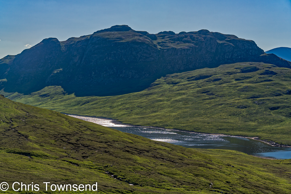 |
| Binnein Shuas & Loch na h-Earba |
I’m glad I visited this area again. It’s how I shall remember it. If the hydro is constructed I doubt I’ll return.
There was a campaign against the hydro scheme. Parkswatch
Scotland ran several excellent piece such as Free
market landscape destruction by Nick Kempe and Shafting
Ardverikie – the fate awaiting its lochs, corries, bens and fine old hill paths
by David Jarmin. The last, which I only read after my walk, describes the Coire
an Iubhair path. The John Muir Trust made
a formal
objection too but all the campaigning was to no avail. A beautiful area of
wild land is to be lost.
Subscribe to:
Posts (Atom)